|
|||||||||||||||||||||||||||||||||||||
Updates- last update 6-21-2020 |
|||||||||||||||||||||||||||||||||||||
Trail and GPS Updates |
|||||||||||||||||||||||||||||||||||||
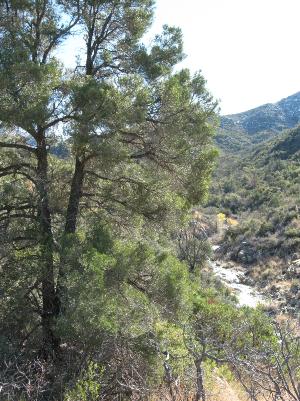
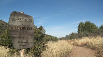
Be sure you set your GPS map datum to the type of map you are using, NAD 27 or NAD 83. In our books and on this website, we always use the NAD 27 map datum. If you want to convert your GPS coordinate format from (dd mm ss), (dd mm), or UTM to another format, enter the coordinates into your GPS unit as a waypoint and then change your GPS unit to the desired format. If you want to convert from the NAD 27 or NAD 83 map datum, you can use the National Geodetic Survey site ngs.noaa.gov. On their home page, select “geodetic tool kit.” On the tool kit page, select “NADCON.” Select “NADCON” again, then select “Interactively Compute.” Enter your coordinates and select “compute.” Massacre Grounds Trail. FR28 to Massacre Grounds Trailhead has been closed to vehicles for several years. The closest parking is at Crosscut Trailhead. No parking is allowed along First Water Road. Wooden trail signs at Crosscut Trailhead point the way to a nice trail that takes you 0.9 miles from the Crosscut Trailhead to the former Massacre Grounds Trailhead. This trail will save you some distance and it is much more scenic than walking on the roads. An open gate (N33° 28' 17.3", W111° 28' 06.2") in the wire fence on the east side of the Crosscut Trailhead parking lot is marked with the “Massacre Grounds” wooden sign. Go straight (east) through the open gate and walk across the concrete slab that was the floor of the former Salt water tank. Cross the sandy wash and watch for rock carins that will take you up to the north end of a flat ridge. Follow the rock cairns to the south end of the ridge (N33° 28' 09.1", W111° 27' 47.1"). Another useful waypoint is at the top of the east side of the large ravine (N33° 28' 02.7", W111° 27' 31.6"). Continue on the track of the rock cairns to the former Massacre Grounds Trailhead at the open gate in the fence (N33° 28' 02.2", W111° 27' 23.5"). The trail is okay for horses except in a few steep spots, so horsemen will have to scout for an alternate route in those areas. From the former Massacre Grounds Trailhead it is another 1.7 miles to the end of the Massacre Grounds Trail. Bull Basin Trail (270). Much work has been done on the trails in the Miles Trailhead area so, in May 2017, we checked the southern end of the Bull Basin Trail. It has been completely restored and is very easy to follow. In May 2017, the Bull Basin wooden sign at the junction with Haunted Canyon Trail was still missing, but we heard that new signage was being installed within a few months. The Haunted Canyon Trail sign at that junction is still there. Paradise Trail (271). We did not travel the complete route of the Paradise Trail, but in May 2017, we saw recent trail work near the south end were it meets the Haunted Canyon Trail and at the summit. Trail crews in the area said that the Paradise Trail has received major maintenance work in 2017. In May 2017, both the Paradise Trail and Haunted Canyon Trail wooden signs (and signpost) were missing at the junction near the dam and dirt tank. Haunted Canyon Trail (203). On our May 2017 trip from FR287A, we observed a new the Haunted Canyon Trail sign near the start of the trail. New water bars near Grapevine Spring have been installed where the trail was washed out and the low-hanging tree across the trail has been removed. The trail was in very good condition with well built water bars and cleared of vegetation. Downhill from the dam and dirt tank the trail is still in good shape. Weavers Needle Crosscut Trail. The waypoint for the junction of the unsigned Terrapin Trail and Weavers Needle Crosscut Trail is (N33° 25' 42.0", W111° 21' 32.8"). The track of the Weavers Needle Crosscut Trail is well defined at this junction. The rectangular butte on the horizon just to the north is a good landmark to let you know you are in the right area. The trail is marked with cairns and is easy to follow. Tonto Trailhead. Parking at the Mining Camp Restaurant parking lot for the Tonto Trailhead has been prohibited since December 2016. We think access is still available for hiking and riding for people living nearby. Please do not park along the residential streets. For access to Siphon Draw, use Lost Dutchman Park where they have nice facilities for hikers and picknickers. Access to the north end Jacob's Crosscut Trail can be made along First Water Road at the Crosscut Trailhead. |
|||||||||||||||||||||||||||||||||||||
|
|||||||||||||||||||||||||||||||||||||
|
|||||||||||||||||||||||||||||||||||||
Be sure you set your GPS map datum to the type of map you are using, NAD 27 or NAD 83. In our books and on this website, we always use the NAD 27 map datum. Tony Ranch. In the fall of 2018, we are in the process of changing the spelling of Tony Ranch, Tony Cabin, and Tony Ranch Spring. In the 1940s, the map makers misspelled Toney as Tony and the ranch was incorrectly known as Tony Ranch for many years. William Toney and his family lived in Haunted Canyon in the early 1900s and the name correction will restore that bit of history. The new spellings are Toney Ranch, Toney Cabin, and Toney Ranch Spring. Hewitt Station Road (FR357). Hewitt Station Road was closed to through traffic on March 24, 2017. Locked gates where the road crosses private property prevent access to FR172 from the east. You need to use the west access to Hewitt Station Road near Queen Valley if you are going to Woodbury Trailhead or Rogers Trough Trailhead. Old Reevis Trail. The Old Reevis Trail between FR650 and Rogers Trough Traihead was restored in September 2017 and it is now part of the Arizona Trail. Previously, the Arizona Trail followed FR650 and FR172A from Montaina Mountain to Rogers Trough Trailhead. The new trail alignment offers some nicer scenery and it will shorten that trail distance. The new section of trail leaves FR650 at a wash crossing (N33° 25' 02.6", W111° 10' 07.2") and goes downhill to the hitching post (N33° 25' 18.7", W111° 10' 21.0") at Rogers Trough Trailhead. Both ends of the new section of trail are marked with Arizona Trail signs. |
|||||||||||||||||||||||||||||||||||||

SuperstitionWildernessTrails.com |
|
Superstition Wilderness Trails
